TESTING REVEALS PFAS CONTAMINATION IN WASHINGTON'S DRINKING WATER NEAR MILITARY BASES

Defense Visual Information Distribution Service | Joint Base Lewis-McChord, WA – Soldiers from 1st Special | https://renopenrose.getarchive.net/media/joint-base-lewis-mcchord-wa-soldiers-from-1st-special-8b20bb | Public Domain Dedication. Public Use Notice of Limitations | https://www.dvidshub.net/about/copyright

In hundreds of drinking water wells near Washington’s military bases, contamination from per- and polyfluoroalkyl substances (PFAS) has been discovered. Testing done by the Department of Defense has identified 866 private drinking water wells contaminated by PFAS, which is nearly half of all wells tested in the state over the last two years.

While public water systems in Washington are mandated to test for PFAS, private wells have no obligations. As of 2022 the military has allocated over $2 billion for investigating its role in polluting communities with PFAS and plans to spend about $7 billion more.

PACIFICORP ORDERED TO PAY AT LEAST $62 MILLION TO HOMEOWNERS FOR 2020 OREGON WILDFIRE DAMAGE

Joe Mabel from Seattle, US | Nye Beach neighborhood, Newport, Oregon. | https://commons.wikimedia.org/wiki/File:Newport_Beach,_OR_-_Nye_Beach_neighborhood_09_%2819311845763%29.jpg |  Creative Commons Attribution-Share Alike 2.0 Generic license. | https://creativecommons.org/licenses/by-sa/2.0/deed.en

PacifiCorp, an Oregon electric utility, was ordered by a state jury to pay at minimum $62 million to nine homeowners whose properties were damaged by wildfires in 2020. Homeowners were awarded $6.3 million to compensate for property damage and economic loss. $56 million was awarded for items such as emotional distress, pain, and suffering. This trial served as one of two test cases to determine how much PacifiCorp owes Oregon residents whose homes were damaged by fires over Labor Day weekend 2020.

PacifiCorp could face billions in liability compensating 5,000 homeowners and business owners who filed a class action against the company in 2020 with claims that the fires damaged around 2,400 properties. A separate jury had already determined PacifiCorp was liable for the fires. The jury found that the company was grossly negligent when it failed to shut down power lines during high winds which sparked and created fires across the state.

DEED ANNOUNCES $2.15 MILLION IN CONTAMINATION CLEANUP GRANTS

Ken Lund from Reno, Nevada, USA | Welcome to Minnesota Near Warroad, Minnesota (43974518701).jpg | https://commons.wikimedia.org/wiki/File:Welcome_to_Minnesota_Near_Warroad,_Minnesota_%2843974518701%29.jpg |  Creative Commons Attribution-Share Alike 2.0 Generic license | https://creativecommons.org/licenses/by-sa/2.0/deed.en  

On January 11, 2024, the Minnesota Department of Employment and Economic Development (DEED) announced a near $2.15 million in Contamination Cleanup and Investigation grants awarded to six communities within the state. The grants cover up to 75% of the costs of removing contamination at polluted sites.  Sites include Gladstone Village in the City of Maplewood which was awarded $402,603 for a 1.58-acre site contaminated with petroleum and other contaminants. The City of Shoreview was awarded $624,693 for a 10.99-acre site that was previously a Ramsey County Public Works facility. The Shoreview site will be redeveloped into a four-story 253-unit apartment building and a 10,000 square foot commercial building.

The grants will clean or investigate almost 27 acres adding around $2 million to local tax baes, create 461 housing units, and leverage over $169 million in private investment.  The Contamination Cleanup and Investigation Grant program has awarded over $207 million in grants since its inception in 1993. These grants have helped to clean 4,065 acres of land, created, or retained 52,030 jobs and cleared the way for 26,660 new housing units.

MAGNITUDE 7.5 EARTHQUAKE SHOCKS WESTERN JAPAN ON NEW YEAR’S DAY

Dead.Rabbit | Japan Garden City Dhaka | https://commons.wikimedia.org/wiki/File:Japan_Garden_City_Dhaka.jpg | CC BY-SA 4.0 DEED, Attribution-ShareAlike 4.0 International | https://creativecommons.org/licenses/by-sa/4.0/deed.en

On January 1, 2024, a 7.5 magnitude earthquake hit Japan causing damage to cities on the Noto Peninsula in the Ishikawa prefecture. The earthquake occurred at a depth of 6.2 miles beneath the Earth’s surface. The epicenter was about 71 miles northeast of Kanazawa and 187 miles northwest of Tokyo.

According to estimates by CoreLogic insured losses could be between $1-$5 billion dollars. The estimates include damage to buildings as well as business interruption and additional living expenses. The Mayor of Suzu said that over 90% of the 5,000 homes in the city have been damaged or destroyed. Following the earthquake NHK reported fires that burned over 100 buildings in central Wajima.

THE EPA LOWERS SCREENING LEVEL FOR LEAD CONTAMINATION IN SOIL IN OMAHA

Roman Eugeniusz | Omaha, Nebraska, USA. | https://commons.wikimedia.org/wiki/File:Omaha_,Nebraska.USA._-_panoramio.jpg | Creative Commons Attribution-Share Alike 3.0 Unported license. | https://creativecommons.org/licenses/by-sa/3.0/deed.en

For the first time in 30 years the Environmental Protection Agency is lowering recommended screening levels for lead in residential soil. The screening level for lead in soil at residential properties will go from 400 parts per million to 200 parts per million. If a residential property is subject to multiple sources of lead exposure the EPA will generally use 100 parts per million as the screening level.

Lowing the recommended screening level is based on updated science and is intended to protect communities. As a result of lowering the recommended screening level the EPA is expected to investigate more residential properties for potential cleanup under the Superfund law and Resource Conservation Recovery Act.

The implications for Omaha’s lead Superfund site will be determined on a site-by-site basis and involve EPA teams and local stakeholders in the local communities to investigate and determine if new screening levels will lead to new site-specific guidelines.

GOV. MILLS DECLARES STATE OF CIVIL EMERGENCY FOR COASTAL COUNTIES IMPACTED BY FLOODING

HURLEY, NY GETS $78K BILL FOR REVIEW OF CONTAMINATED FORMER LANDFILL

Daniel Case | A mid-channel bar just above a wider meander at a bend of Esopus Creek in Hurley, NY, USA | https://commons.wikimedia.org/wiki/File:Mid-channel_bar_in_Esopus_Creek_at_Hurley,_NY.jpg |  Creative Commons Attribution-Share Alike 4.0 International license | https://creativecommons.org/licenses/by-sa/4.0/deed.en

The town of Hurley, New York was subject to a draft consent order from the state seeing $77.976.58 for work that would identify the former town landfill as a contaminated Superfund site. The order also requires Hurley to develop a citizens’ participation plan. The goal of the plan is to involve residents’ input on cleanup and future management of the landfill site.

A ‘preliminary’ designation to the former landfill was issued as a result of activities and incidents that have resulted in a heightened level of concern with how much contamination is leaching from the site. Testing at the landfill found leachate overflowing with PFOA and PFOS in private wells down-gradient of the site.

DAMAGE DONE TO MAINE WORKING WATERFRONT

Stilfehler | Docks in Portland, Maine | https://commons.wikimedia.org/wiki/File:Docks_in_Portland_Maine_-_August_2008.jpg |  Creative Commons Attribution-Share Alike 1.0 Generic | https://creativecommons.org/licenses/by-sa/1.0/deed.en  

Wind and rainstorm on January 10 caused unprecedented damage to property along Maine’s working waterfront. Maine Forest Service will conduct an aerial survey along the coast to document the damage. The 13.84-foot high tide in Portland was the third highest on record. The forecast storm for January 13 came with a projected tide 1 foot higher than January 10. Roadways and buildings from St. George through Lincolnville Beach were flooded. The Landings Marina in Rockland was heavily damaged. The pier there was destroyed and buildings were left teetering. A small cabin in Owls Head was washed off its foundation and sent onto Crescent Beach. Local fire departments responded to evacuation calls where people were trapped by rising waters.

HUGE WAVES DAMAGE HOMES ALONG CALIFORNIA COAST

Defense Visual Information Distribution Service | Homes and streest of neighborrhood affected by the waves | https://www.dvidshub.net/ | Public Domain Dedication. Public Use Notice of Limitations | https://www.dvidshub.net/about/copyright

California’s first huge swells of winter wreaked havoc on the coastline. Beaches and coastal roads flooded. An incoming atmospheric river storm forced evacuations. Extreme weather conditions caused several injuries, flooding, and evacuation orders at coastal cities throughout the state. Ventura County reported waves up to 12 feet. The Central Coast reported 18- to 20-foot swells. Large waves near South Seaward Avenue in Ventura County caused flooding and injury. Eight people sustained minor to moderate injuries and were taken to the hospital. Ventura County Fire Department rescued 15 people out of the ocean during high tide. A boutique hotel located on the beach, Inn On The Beach, was closed after a wave slammed into the hotel and flooded rooms with nearly 2 feet of water. No guests were injured, though some were stuck in their rooms for a short time. About 45 guests were evacuated from the hotel.

All beaches in Ventura County were closed when waves reached the streets. Evacuation orders were issued for Marin County, and residents were ordered to evacuate to Stinson Beach Community Center. Santa Cruz County issued an evacuation warning for costal areas near Seacliff State Beach due to flooding. There was a coastal flood warning for the Bay Area due to large breaking waves that caused significant flooding of beach and coastal roads. In Monterey County, Point Lobos State Natural Reserve was rendered unsafe due to high surf washing into trails.

UTAH TO RECEIVE FEDERAL EMERGENCY FUNDS FOR DAMAGE CAUSED DURING SPRING FLOODING

Defense Visual Information Distribution Service | Utah National Guard activated to assist with Hildale, Utah, flood search and recovery mission | https://garystockbridge617.getarchive.net/media/utah-national-guard-activated-to-assist-with-hildale-utah-flood-search-and-e89c6d | Public Domain Dedication. Public Use Notice of Limitations: https://www.dvidshub.net/about/copyright | https://creativecommons.org/publicdomain/mark/1.0/

Record snowfall caused floods in Utah. Utah Governor Spencer Cox declared a state of emergency on April 18, 2023. Now, five counties will receive federal emergency funds to aid in their recovery. Iron, Morgan, Sanpete, Utah, and Wasatch counties will receive the federal aid to repair and replace damaged public property. The federal funds will not go toward private residences or other property damage. Many repairs to roadways, drainage systems, and water facilities are in progress or completed already.

JAPAN HIT BY MAGNITUDE 7.6 EARTHQUAKE, STRUCTURAL DAMAGE AND TSUNAMI REPORTED

Defense Visual Information Distribution Service | The remnants of a house lies in rubble | https://www.dvidshub.net/ | Public Domain Dedication. Public Use Notice of Limitations | https://www.dvidshub.net/about/copyright

At the start of a new year, Japan experienced a 7.6 magnitude earthquake that caused widespread reports of damage. Thousands evacuated the coast due to the first major tsunami warning since 2011. The earthquake hit the Noto peninsula region of the Ishikawa prefecture. It was the strongest earthquake recorded in the region since 1885. The potential major tsunami event was later downgraded and is no longer cited as “major.”

At least 30 buildings collapsed in Ishikawa. The earthquake was felt widely. Buildings swayed in Tokyo and cities further from the epicenter, such as Kaga, also reported damages. Properties and structures across a relatively wide area of the western region of Japan were damaged by these events.

AMID POLLUTED WATER AND CLIMBING CANCER RATES, IOWA EYES FARM CHEMICALS

U.S. Department of Agriculture via Picryl.com |  Contour farming and conservation tillage protect highly erodible land on a farm near Norwalk in Warren County, in central Iowa. | https://picryl.com/media/nrcsia99534-iowa-3743nrcs-photo-gallery-996f3a | PDM 1.0 DEED, Public Domain Mark 1.0 Universal | https://creativecommons.org/publicdomain/mark/1.0/

Iowa public health officials respond to high cancer rate by cutting exposure to potential cancer-causing chemicals used in agriculture. Iowa plans to limit exposure to pesticides, commercial fertilizer, and animal manure. The Iowa Cancer Consortium is a coalition of public health professionals, researchers, and health providers focused on controlling cancer. The consortium is working to reduce cancer by addressing environmental factors.

Iowa has the second highest cancer incidence rate in the United States. From 2015 to 2019, Iowa was the only state where the rate of new cancers increased. The state is expected to see 21,000 new cases of cancer this year. Iowa farmers spread more pesticides, commercial fertilizer, and animal manure each year than any other state. Farm pollutants contaminate the surface and groundwater across Iowa, potentially exposing people who do not live or work on farms. Farm contaminants and nitrates in drinking water have been linked to cancer. As much as 70% of the nitrogen in fertilizer and manure is not used by the crops but drains into ground and surface water as nitrate.

WANT TO KNOW IF YOUR FUTURE HOME MIGHT FLOOD? THESE STATES ARE REQUIRING DISCLOSURE

Willthacheerleader18 | Houses in the historic Walltown neighborhood in Durham, North Carolina | https://commons.wikimedia.org/wiki/File:Walltown,_Durham,_North_Carolina_1.jpg | CC BY-SA 4.0 DEED, Attribution-ShareAlike 4.0 International | https://creativecommons.org/licenses/by-sa/4.0/  

North Carolina Real Estate Commission passed new disclosure rules requiring detailed flood risk information for home buyers. Sellers must now reveal flood insurance status, past claims, and federal assistance received due to flooding. This follows similar moves in South Carolina, New York and New Jersey, acknowledging increasing flood risks nationwide.

Advocates stress the importance of transparency. However, many states still lack such requirements. Calls for federal action persist, but individual state initiatives aim to empower buyers with crucial flood-related information to help make more informed decisions.

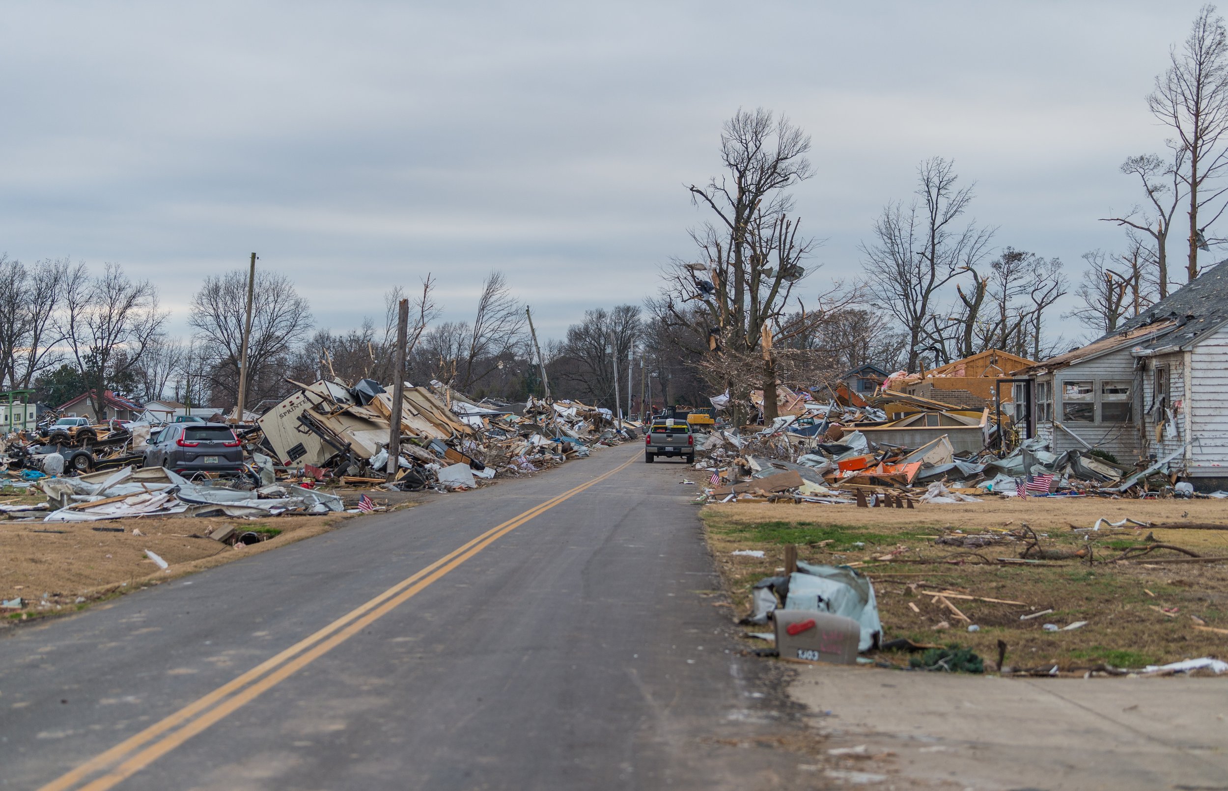
FAMILY OF FIVE SURVIVE TORNADO, BATHROOM STALL ONLY THING LEFT STANDING

State Farm | 2021 December Tornado - Samburg, TN | https://www.flickr.com/photos/statefarm/51752209814/ | CC BY 2.0 DEED, Attribution 2.0 Generic | https://creativecommons.org/licenses/by/2.0/

LEGAL LIABILITY FOR SOIL CONTAMINATION IN MEXICO

JOMA-MAC | The facade of the National Palace in Mexico City, once seat of the viceroy of New Spain when part of the Spanish Empire. | https://www.worldhistory.org/image/16029/national-palace-mexico-city/ | Creative Commons Attribution-ShareAlike | https://creativecommons.org/licenses/by-sa/4.0/

In real estate transactions in Mexico, considering environmental issues can be crucial due to potential liabilities and long-term consequences. Soil contamination can go unnoticed during acquisition, becoming evident later. Parties involved may be held responsible for remediation, as per Mexico’s laws, regardless of whether they caused the pollution.

It’s can be important to conduct environmental studies before purchasing or leasing property in Mexico to assess contamination risks and legal implications. Additionally, evaluating project feasibility and compliance with environmental laws at all government levels should be considered. Recognizing and addressing these environmental aspects can be important to mitigate risks and liabilities in real estate development and projects.

THEIR NEIGHBORS LOST EVERYTHING IN A MASSIVE LANDSLIDE. NOW THEY FEAR FOR THEIR HOMES

John Murphy | Wide shot of Western Side. (Palos Verdes) | https://commons.wikimedia.org/wiki/File:Palos_Verdes_%283297223611%29.jpg | CC BY-SA 2.0 DEED, Attribution-ShareAlike 2.0 Generic | https://creativecommons.org/licenses/by-sa/2.0/

The residents of Peartree Lane in Rolling Hills Estates are grappling with the aftermath of a devastating landslide that occurred last July. Sepideh Razipour, who had recently become a homeowner, found her dreams shattered when the hillside below her home gave way. Before Sepideh and her husband made their first mortgage payment, a massive landslide upended life on Peartree Lane, pulling eight neighbors’ homes down a nearby canyon. Her house wasn’t damaged but has been yellow-tagged and is still unlivable because of sewer damage.

Efforts to stabilize the slope are underway, with homeowners shouldering the financial burdens. The city has provided limited assistance, and FEMA reimbursement remains pending. The two HOAs in the gated Rolling Hills Park Villas have been ordered by the city to implement winterization measures to mitigate stormwater runoff and erosion and halt further damage to the canyon.

‘FOREVER CHEMICALS’ FOUND IN DRINKING WATER SOURCES ACROSS ENGLAND

Pixabay.com | A large body of water surrounded by trees. Grasmere England, Great Britain | https://garystockbridge617.getarchive.net/media/grasmere-england-great-britain-nature-landscapes-56a171 | PDM 1.0 DEED, Public Domain Mark 1.0 Universal | https://creativecommons.org/publicdomain/mark/1.0/

Per- and polyfluoroalkyl substances (PFAS) – a group of 10,000 or so human-made chemicals widely used in industrial processes, firefighting foams and consumer products have been detected in drinking water sources at 17 of 18 England’s water companies. With 11,853 samples testing positive. PFAS have been linked to cancer, thyroid disease, immune system and fertility problems as well as developmental defects.

Affinity Water looks to have the larges PFAS problem with 73 raw water samples above the maximum Drinking Water Inspectorate (DWI) limits at five sites followed by Anglian with 22 samples and Southern Water with two samples. The Royal Society of Chemistry (RSC) is pushing for a tenfold redulction of the limit for individual PFAS types. This would bring England and Wales closer to EU and Scotland. Additionally, the RSC wants to see more regular monitoring and creation of a chemicals agency to deal with PFAS and other contaminants.

RESIDENTS OF ATLANTA APARTMENT THAT BURNED TO FILE LAWSUIT AGAINST PROPERTY OWNERS

Carol M. Highsmith | Martain Luther King, Jr., Federal Building, Atlanta, Georgia | https://picryl.com/media/martin-luther-king-jr-federal-building-atlanta-georgia-1 | Public Domain Creative Commons License | https://picryl.com/media

At the Reserve at LaVista Walk in Atlanta hundreds watched their homes burn for hours on November 10, 2023. Attorneys with the Dean Thaxton law firm claimed that the building had a damaged fire suppression system and that property owners prioritized profit over safety. According to a December 2022 fire inspection report the Atlanata Fire Rescue Department did not find the complex to be out of code.

The fire started when two people set off fireworks on the roof of the building. Fire Chief Rod Smith described the blaze as a complete anomaly because it started on the roof which may have delayed the alarm and sprinkler systems. Dean said the property had several issues with the fire suppression system including broken control valves and corroded sprinkler heads.

The fire burned overnight and most of the day on Nov 11 and required more than 80 firefighters. All of the residents were able to evacuate but 17 people were treated for smoke inhalationa and various minor injuries.

DEVON FARM FINED OVER £4K FOR POLLUTING WATERCOURSE WITH SLURRY

IowaCapitalDispatch.com

Bycott Farm of Halberton, Devon, was fined £4,300 for polluting a watercourse with slurry. The company was additionally ordered to pay £1,765 and a victim surcharge of £190 for two charges that include an incident of disposal of controlled waste in a manner likely to cause environmental pollution or harm human health. Environmental Agency officers traced the source of pollution back to the farms where owners Stephen and Tom Dibble confirmed that water from yards between cattle sheds drained to a pipe discharging water into a stream.

Investigations two months later found polluted water still flowing into the ditch where thick sewage fungus was visible for more than two kilometres downstream. In an interview with the Envionment Agency Stephen Dibble said the dairy herd had an increase in size in recent years to over 1,000 cows.

TORNADO DAMAGES AT LEAST 10 HOMES IN ARIZONA TOWN OF STAR VALLEY

ABC15.com

A tornado hit the town of Star Valley, Arizona prompting the National Weather Service’s Flagstaff branch to survey damage to the area. The damage indicated an EF-1 tornado with peak winds ranging from 95 to 105 mph. Nobody was hurt in the tornado however one dog was killed by the gusts and 10 homes were damaged from the wind.